Mooselookmeguntic Lake Fishing Spot
- Max Depth: 139'
- Elevation: 1475'
- Last Modified By: vinny60 on 09/11/09 10:42 PM
- Ask about Mooselookmeguntic Lake in our Fishing Forums
Photos
Fish Species
Comments
-
Have you fished at Mooselookmeguntic Lake? Be the first to comment on this fishing spot.
Mooselookmeguntic Lake Description
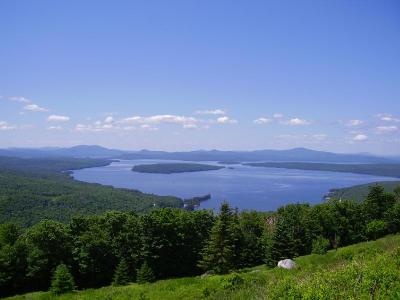
The name Mooselookmeguntic is said to have originated from an ancient Abanaki word. It means portage to the moose feeding place, or moose feeding among the trees. This lake is 16,300 acres in size, the second largest in Maine, and is famous for its recreation opportunities and magnificent scenery. Mooselookmeguntic Lake is full of salmon, brook trout fallfish, brown trout and many other types of fish, bringing fisherman from all areas to the lake. There are two large islands in the southern portion of Mooselookmeguntic Lake called "Toothaker Island" and "Students Island". Hiking trails around the area also provide campers and day- trippers with beautiful views of the area. Just three miles from Rockery campground on the Mooselookmeguntic Lake is the Appalachian Trail, which provides a route to the Height of Land Overlook, which offers a spectacular view of the lake and surrounding areas. The land surrounding Mooselookmeguntic Lake boasts 9 major protected land parcels. These parcels are public access and can be used for recreation such as camping, walking and hiking the trails, and wildlife viewing.
Mooselookmeguntic Lake is located in Franklin County and Oxford County, Maine, in the United States. It is part of the Androscoggin River watershed.