Allagash Lake Fishing Spot
- Mean Depth: 35'
- Max Depth: 89'
- Elevation: 1037'
- Last Modified By: vinny60 on 09/04/09 12:32 PM
- Ask about Allagash Lake in our Fishing Forums
Photos
Fish Species
Comments
-
Have you fished at Allagash Lake? Be the first to comment on this fishing spot.
Allagash Lake Description
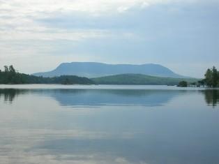
Allagash Lake can easily be called the gem of the north Maine woods. It was ranked by the Maine Sportsman as one of Maine's top ten trout waters. Just the scenery alone is well worth the trip in, but add to that the fantastic fishing for native brookies and you have something very special. Getting to Allagash Lake is no easy task though. First of all Allagash Lake is located in the North Maine Woods about 80 road miles(most of which is gravel) north of Greenville on Moosehead Lake. You must pay a fee to enter the NMW's checkpoints into this area. Once you get close to the lake the work begins, there are several access points. The first one is the canoe launch on Allagash Stream about 4 miles above the lake. The other water access point is Johnson Pond also about 4 miles above the lake. Access to the lake from these points is usually fairly easy but remember there is absolutely no road access to the lake so you must drag your canoe back up stream to the put in points. These access points are located on the northwest side of the lake.The other two access points are not any easier. They are located on the south end of the lake. Both are portage trails that are a mile long. The first of these is The Carry Trail on the far south end of the lake. The second access trail is to the Islands campsite on the southeast end of the lake. A canoe carrier with wheels makes access to these two point much easier.Once you are in on Allagash Lake there are eight campsites located at various points around the lake. These campsites are maintained by the Allagash Wilderness Waterway Rangers and there is a fee to stay in them. The only lodging in the area is three miles south of Allagash Lake at Loon Lodge on Round Pond.